Showing posts with label Fun map stuff. Show all posts
The town in two states
The fine folks of Price Place, Arkansas seem to live in two states simultaneously. They pay taxes to Arkansas, but their kids go to Missouri schools. Their Arkansas drivers licenses say they live in Missouri. It's really weird. And now it's about to change. These Arkansas residents will actually get Arkansas addresses... and they are really mad about it. Yeah, I don't get it either, but one thing is clear: this is one state border that should be re-routed. You can get the full story here.
Labels:
Fun map stuff
All 50 states mentioned in movies
I'm not sure how anyone could have enough free time to create this, but I'm glad they did. If you are studying state capitals in school, or just curious, here are all 50... through snippets in movies.
Labels:
Fun map stuff
Young state riddle
Just four US states are less than 100 years old. Can you name them? Two are so easy, I included them on the map above: Alaska and Hawaii. But can you name the other two youngsters? The answer is here.
Labels:
Fun map stuff
County named after killer
So an outsider comes to town and shoots one of the locals dead in cold blood. The shooter is then hailed as a hero, and the townfolk decide to name a county after the killer. This is the true story of Louisa County, Iowa.
In the 1830s, William Smith wanted a mining claim owned by the Massey family. So Smith and his son shot and killed Woodbury Massey... and then rode through town proclaiming that they'd kill any other Masseys they could find. At this point, Woodbury Massey's brother, Henry, took preemptive action and killed William Smith. Then the story gets interesting. 16-year-old Louisa Massey, sister of Woodbury and Henry, arrives in town and cooly proclaims she's just doing some shopping. But when she spots the younger Smith in the store, she pulls out a gun and shoots him dead too.
Louisa became an instant hero. Newspaper reports wrote: "The upper river county went wild with her praise. No war hero was ever welcomed with greater enthusiasm... cheering throngs greeted her at every stop." What is the moral of this story? I have no idea. Certainly, no one today wants 16-year-old girls involved in revenge killings. It might be one thing to exonerate Louisa, but to make her a hero, and name a county after her? It all seems very strange. You might explain it by saying that times were different then; but after Lincoln was shot, nobody was clamoring to create John Wilkes Booth county. About the only explanation I can come up with: the Smiths must have been some really mean and nasty dudes.
You can read contemporaneous news reports about Louisa Massey here. And a book here. (Another great story for a screenwriter. But who to play Louisa? Hailee Steinfeld? Dakota Fanning? Selena Gomez?) Tweet
In the 1830s, William Smith wanted a mining claim owned by the Massey family. So Smith and his son shot and killed Woodbury Massey... and then rode through town proclaiming that they'd kill any other Masseys they could find. At this point, Woodbury Massey's brother, Henry, took preemptive action and killed William Smith. Then the story gets interesting. 16-year-old Louisa Massey, sister of Woodbury and Henry, arrives in town and cooly proclaims she's just doing some shopping. But when she spots the younger Smith in the store, she pulls out a gun and shoots him dead too.
Louisa became an instant hero. Newspaper reports wrote: "The upper river county went wild with her praise. No war hero was ever welcomed with greater enthusiasm... cheering throngs greeted her at every stop." What is the moral of this story? I have no idea. Certainly, no one today wants 16-year-old girls involved in revenge killings. It might be one thing to exonerate Louisa, but to make her a hero, and name a county after her? It all seems very strange. You might explain it by saying that times were different then; but after Lincoln was shot, nobody was clamoring to create John Wilkes Booth county. About the only explanation I can come up with: the Smiths must have been some really mean and nasty dudes.
You can read contemporaneous news reports about Louisa Massey here. And a book here. (Another great story for a screenwriter. But who to play Louisa? Hailee Steinfeld? Dakota Fanning? Selena Gomez?) Tweet
Labels:
Fun map stuff
Sitcom quiz - Packerland version
You expect TV sitcoms to be set in Los Angeles or New York. But Wisconsin? Sure enough, at least five major sitcoms have been set in the Dairy state. Why is Wisconsin so popular? I have no idea. But as a Wisconsinite, I do get a laugh every time I see mountains in the background on one of these shows. Or actors who try to have a Wisconsin accent, but invariably sound Chicago-ish. Anyway, you can see the 5 shows identified here. And if you can think of any others, let me know...
Labels:
Fun map stuff
One letter wrong
Yesterday I was driving through Tichigan. Yes, you read that right. There is a small town on Wisconsin named Tichigan. Passing through, I wondered: how many times do they have to say, "It's Tichigan, not Michigan"? It must be exhausting. That made me think there must be other places that are one letter off from famous locations—causing endless confusion. Like the beleaguered folks from Milwaukie, Oregon... or residents of The Dalles, Oregon (who at least have that weird "The" at the beginning to prevent complete confusion with Dallas, Texas). My personal favorite is a small town in Wisconsin named Arkansaw... yeah, with a "w" (above). Of course, the biggest example of this problem is Iran and Iraq; Tim Pawlenty embarrassed himself badly mixing up the two recently. Maybe that's why he left the race. See, geography really is important!
Labels:
Fun map stuff,
In the news
Obama's secession secret?
There's been a lot of criticism of Rick Perry's talk of Texas secession, but at least he's not giving his vacation dollars to a government that recently voted to secede—like President Obama is. OK, it's a stretch, I admit... but it is kind of funny that Obama is vacationing on Martha's Vineyard—one of the only places in the north that actually voted in favor of secession. And it wasn't centuries ago... it was 1977. The people of Martha's Vineyard and Nantucket were so mad at Massachusetts, they actually voted to leave the state. There was some talk of forming a new country, but most of the proposals had Nantucket and Martha's Vineyard joining Vermont. Or perhaps Hawaii. Yeah, Hawaii offered an invitation. Wait a minute, that's where Obama's from! Conspiracy theorists, start your engines!
OK, nobody actually believes that President Obama sides with Martha's Vinyard's lingering secessionists. So if secession came up, on say, a political talk show, I'd expect Obama's spokespeople to deny any silly secessionist talk. Wait a second! Obama's campaign advisor Robert Gibbs can't seem to stop talking about secession! And press secretary Jay Carney is no better. Yes, I know they are poking at Perry, but it strikes me as odd to point the "He's a secessionist" finger when their man is actually staying on Secession Island.
Labels:
Fun map stuff,
Lost States
Criminal Corner - Another spot for the perfect crime?
Yesterday we laid out the case made by legal scholar Brian Kalt that major crimes committed in the Idaho portion of Yellowstone National Park can not be prosecuted because of a legal loophole. Reader DanV wisely wondered why the same situation wouldn't also apply to the Montana portion of the park.
It does, sort of. Remember, the reason criminals would go free in Loophole Land is because a jury could not be formed from residents of the required location (the Idaho portion of the park) because no one lives there. But the Montana portion of the park does have residents... about 40 of them. That said, a sharp lawyer could argue that 40 people isn't enough of a pool from which to draw a jury, but a judge could reasonably disagree.
But if your heart is set on committing the perfect crime in Montana's "Criminal Corner" you do have one other option—get your buddies to do the same thing. While 40 residents might be enough for one jury, it wouldn't be enough for 3 or 4 simultaneous trials. So if you and your friends commit multiple crimes... and draw straws... only the loser would likely face a trial. That's because—by the time the 3rd or 4th trial could be scheduled—too much time would have passed for the "speedy" trial required by law.
But again, don't try this at home. Crime is bad. Prof. Kalt agrees... he just wants the loophole closed.
It does, sort of. Remember, the reason criminals would go free in Loophole Land is because a jury could not be formed from residents of the required location (the Idaho portion of the park) because no one lives there. But the Montana portion of the park does have residents... about 40 of them. That said, a sharp lawyer could argue that 40 people isn't enough of a pool from which to draw a jury, but a judge could reasonably disagree.
But if your heart is set on committing the perfect crime in Montana's "Criminal Corner" you do have one other option—get your buddies to do the same thing. While 40 residents might be enough for one jury, it wouldn't be enough for 3 or 4 simultaneous trials. So if you and your friends commit multiple crimes... and draw straws... only the loser would likely face a trial. That's because—by the time the 3rd or 4th trial could be scheduled—too much time would have passed for the "speedy" trial required by law.
But again, don't try this at home. Crime is bad. Prof. Kalt agrees... he just wants the loophole closed.
Labels:
Fun map stuff,
In the news,
Map blunders
Loophole land—where crimes can't be prosecuted. Really.
According to a law professor from Michigan, there is small section if Idaho where major crimes can not be prosecuted—thanks to a giant blunder by Congress.
The problem begins with the boundaries of Yellowstone National Park. Yellowstone is mostly in Wyoming, but a sliver of the park extends into Idaho and Montana. When Congress created the U.S. District Court of Wyoming it included all of Yellowstone National Park. Big mistake.
Stay with me here.... so let's say you commit a murder in the portion of Idaho that's in the park (The red "Loophole Land" on my map). You'd be arrested and bound over for trial in the US District court in Cheyenne, Wyoming. But Article III of the Constitution states that the trial must be held in the state where the crime was committed—in this case Idaho. So you are sent to Idaho for trial. No problem there. But the Sixth Amendment also says that the jury must be drawn from the state and District where the crime was committed. The state is Idaho... but the District is the Wyoming District (which includes the sliver of Idaho that's in the park). So the jury would have to be drawn from residents who live in the portion of Idaho that lies in the park.
And that's where it gets interesting: nobody lives in that patch of Idaho. Nobody. No jury pool means no trial, means you go free.
This curious loophole was discovered by Prof. Brian C. Kalt, a respected legal scholar from Michigan State University. Georgetown Law Journal is reporting on the matter in an upcoming issue. (You can read Kalt's full article here)
Of course, committing crimes is bad. Don't do it. But if you're a screenwriter, this is great stuff! Maybe Dick Wolf will start a new series Law and Order: Idaho just to take advantage of this legal anomaly.
And if all this wasn't bizarre enough, Idaho's "Loophole Land" is just a few steps from another patch of American soil that also fell outside the law. Dubbed "Lost Dakota" it was a few acres of land that—erroneously—were not part of any state and thus, theoretically, outside the reach of law enforcement. (Much more on this in my book Lost States) Eventually that situation was fixed when Lost Dakota became a part of Montana. But Loophole Land remains an unsettling, well, loophole. If your nemesis suggests a camping trip near the Idaho/Wyoming border.... don't go!!!
The problem begins with the boundaries of Yellowstone National Park. Yellowstone is mostly in Wyoming, but a sliver of the park extends into Idaho and Montana. When Congress created the U.S. District Court of Wyoming it included all of Yellowstone National Park. Big mistake.
Stay with me here.... so let's say you commit a murder in the portion of Idaho that's in the park (The red "Loophole Land" on my map). You'd be arrested and bound over for trial in the US District court in Cheyenne, Wyoming. But Article III of the Constitution states that the trial must be held in the state where the crime was committed—in this case Idaho. So you are sent to Idaho for trial. No problem there. But the Sixth Amendment also says that the jury must be drawn from the state and District where the crime was committed. The state is Idaho... but the District is the Wyoming District (which includes the sliver of Idaho that's in the park). So the jury would have to be drawn from residents who live in the portion of Idaho that lies in the park.
And that's where it gets interesting: nobody lives in that patch of Idaho. Nobody. No jury pool means no trial, means you go free.
This curious loophole was discovered by Prof. Brian C. Kalt, a respected legal scholar from Michigan State University. Georgetown Law Journal is reporting on the matter in an upcoming issue. (You can read Kalt's full article here)
Of course, committing crimes is bad. Don't do it. But if you're a screenwriter, this is great stuff! Maybe Dick Wolf will start a new series Law and Order: Idaho just to take advantage of this legal anomaly.
And if all this wasn't bizarre enough, Idaho's "Loophole Land" is just a few steps from another patch of American soil that also fell outside the law. Dubbed "Lost Dakota" it was a few acres of land that—erroneously—were not part of any state and thus, theoretically, outside the reach of law enforcement. (Much more on this in my book Lost States) Eventually that situation was fixed when Lost Dakota became a part of Montana. But Loophole Land remains an unsettling, well, loophole. If your nemesis suggests a camping trip near the Idaho/Wyoming border.... don't go!!!
Labels:
Fun map stuff,
In the news,
Lost States,
Map blunders
When Hawaii was Russian
Hawaii became a U.S. state 52 years ago yesterday. One long-forgotten chapter in Hawaii's history is when the Russians tried to take control of the islands. Back in the early 1800s, Hawaii was a coveted port for whalers. So, in 1816, the Russians began building a fort on Oahu, hoping to control the islands. King Kamehameha I would have none of it, and forced them off the island without any bloodshed. But the Russians didn't go home. Instead, they tried to build their fort on nearby Kauai. When Kamehameha found out, he took more severe action—deporting the Russians to California. This ended Russia's plans in Hawaii, opening the door for the United States a few decades later.
(There's a terrific article about the statehood struggle of Hawaii (and the possibility of a 51st state) in yesterday's Buffalo News—written by Alexander Heffner.)
Labels:
Fun map stuff,
New states?
The place that's name shall not be spoken
I'm not going to write the name of this place, because I fear Google will put up some weird ads. Hey, this is a family-friendly site! Still, it's a real place in Macon County, Georgia—between Mooney Gap and Bearpen Gap. You have to admit that it's kind of funny that there is a place with that name. If fact there are several. The term means an "abrupt, broken off end of a ridge or mountain." OK, sure. Your can read about this and other odd place names here.
Labels:
Fun map stuff
Is Kansas flatter than a pancake?
Scientists at Arizona State and Texas State have focused considerable research energy on one of the great questions of our time: Is Kansas really flatter than a pancake? Of course, they used the standard measure of flatness: The length of an ellipse’s semi-major axis A is compared with its measured semi-minor axis B using the formula for flattening, f = (a – b) / a. Of course.
Using a standard IHOP pancake, the team calculated a flatness of .957, which is flat, but shy of perfect flatness (which would be a 1.0). Applying the same formula to the topography of Kansas, the scientists came up with .9997, which is much much flatter than a pancake. So it's not really right to drive through Kansas and say, "This place is as flat as a pancake." However, if you ever went to IHOP and got a particularly flat pancake, you would be OK in saying, "This pancake is a flat as Kansas."
Thank university scientists by Mark Fonstad, William Pugatch, and Brandon Vogt, for solving this vexing question.
Using a standard IHOP pancake, the team calculated a flatness of .957, which is flat, but shy of perfect flatness (which would be a 1.0). Applying the same formula to the topography of Kansas, the scientists came up with .9997, which is much much flatter than a pancake. So it's not really right to drive through Kansas and say, "This place is as flat as a pancake." However, if you ever went to IHOP and got a particularly flat pancake, you would be OK in saying, "This pancake is a flat as Kansas."
Thank university scientists by Mark Fonstad, William Pugatch, and Brandon Vogt, for solving this vexing question.
Labels:
Fun map stuff
Garden of Eden - located!
Has the Garden of Eden been located? New scientific research, coupled with coordinates laid out in the Bible itself, mean it may indeed be possible to determine the garden's location on a modern map. This shouldn't be all that surprising of a development. Archeology consistently validates the historicity of Biblical geography. Even non-believing archeologists recognize that the Bible describes real places. (For lots more on this, here's a great article by my favorite author Paul L. Maier)
But what about the Garden of Eden? Most Christians believe it was a real place, but unlike Jerusalem or Rome, its ancient location is not obvious. Yet the Bible does offer a surprisingly detailed description of the Garden of Eden's location. The problem has always been that that researchers could not find two of the rivers mentioned in the Biblical description. Modern hydrological sciences have recently solved that problem, giving scientists all the data necessary to triangluate the Garden of Eden.
But the data didn't add up. Until recently, that is—when Phd hydrologist Ward Sanford offered an elegant solution. You can read his full report here (scroll down for the details). But first, watch our video above to find out where the Garden of Eden likely was (or is).
But what about the Garden of Eden? Most Christians believe it was a real place, but unlike Jerusalem or Rome, its ancient location is not obvious. Yet the Bible does offer a surprisingly detailed description of the Garden of Eden's location. The problem has always been that that researchers could not find two of the rivers mentioned in the Biblical description. Modern hydrological sciences have recently solved that problem, giving scientists all the data necessary to triangluate the Garden of Eden.
But the data didn't add up. Until recently, that is—when Phd hydrologist Ward Sanford offered an elegant solution. You can read his full report here (scroll down for the details). But first, watch our video above to find out where the Garden of Eden likely was (or is).
Labels:
Fun map stuff,
In the news
Naming rights for Tennessee
Should the state of Tennessee sell naming rights as a way to make money? The idea was floated the other day by Knoxville humorist Scott McNutt. Of course, McNutt was making a joke, but one major city actually did sell off naming rights to large corporation. And it retains the company name to this day. (More on this here and here.) Anyway, McNutt suggested selling Tennessee's naming rights to Pilot/Flying J... but I think that one of Tennessee's bigger employers would be a more natural fit. How about "Fedexessee"? It kind of rolls off the tongue nicely. Of course, the state flag would have to be updated to purple and orange. Got a better idea? Add your suggestions.
Labels:
Fun map stuff
Ironic Grant County
Grant County, Oregon voted to declare itself a "United Nations-Free Zone" over concerns that the UN has plans to send in the black helicopter fleet, confiscate everyone's guns, and and enslave the local children (oh, wait, that last part's from TNT's new series Falling Skies). The fact that Grant county wants to separate itself from the rest of the USA isn't all that unusual, but it seems that no one there gets the irony. You see, Grant county is named for Ulysses S. Grant. 150 years ago, when another group of citizens didn't like what the government was doing, Ulysses Grant led the army that put a stop to the uprising. It's kinda like Bourbon county, Kansas—where bourbon is illegal. It's funny... and the irony makes it hard to take them too seriously. So maybe the first step Grant County should take is to change its name.... maybe rename itself after some famous statesman who was against the United Nations. I can see the sign now, "Welcome to Charles de Gaulle county, Oregon."
(Read more about Grant county's anti-UN ways in this article by Jason Plautz)
Labels:
Fun map stuff
The unfriendly place?
Above is an unretouched detail from a very popular map... can you guess what place this is? Note the politically incorrect "Unfriendly Indian" village... a settler's cabin that's been set on fire (presumably by the unfriendly Indians); even arrows sticking out of the cabin, from the Indians' attempt to kill the settlers. Still don't know where this is? Here's a hint. You've probably been there. I was—at age 7—just five years after this map was created. (For the answer, see the full map here.)
Labels:
Fun map stuff
The map that made Colorado angry
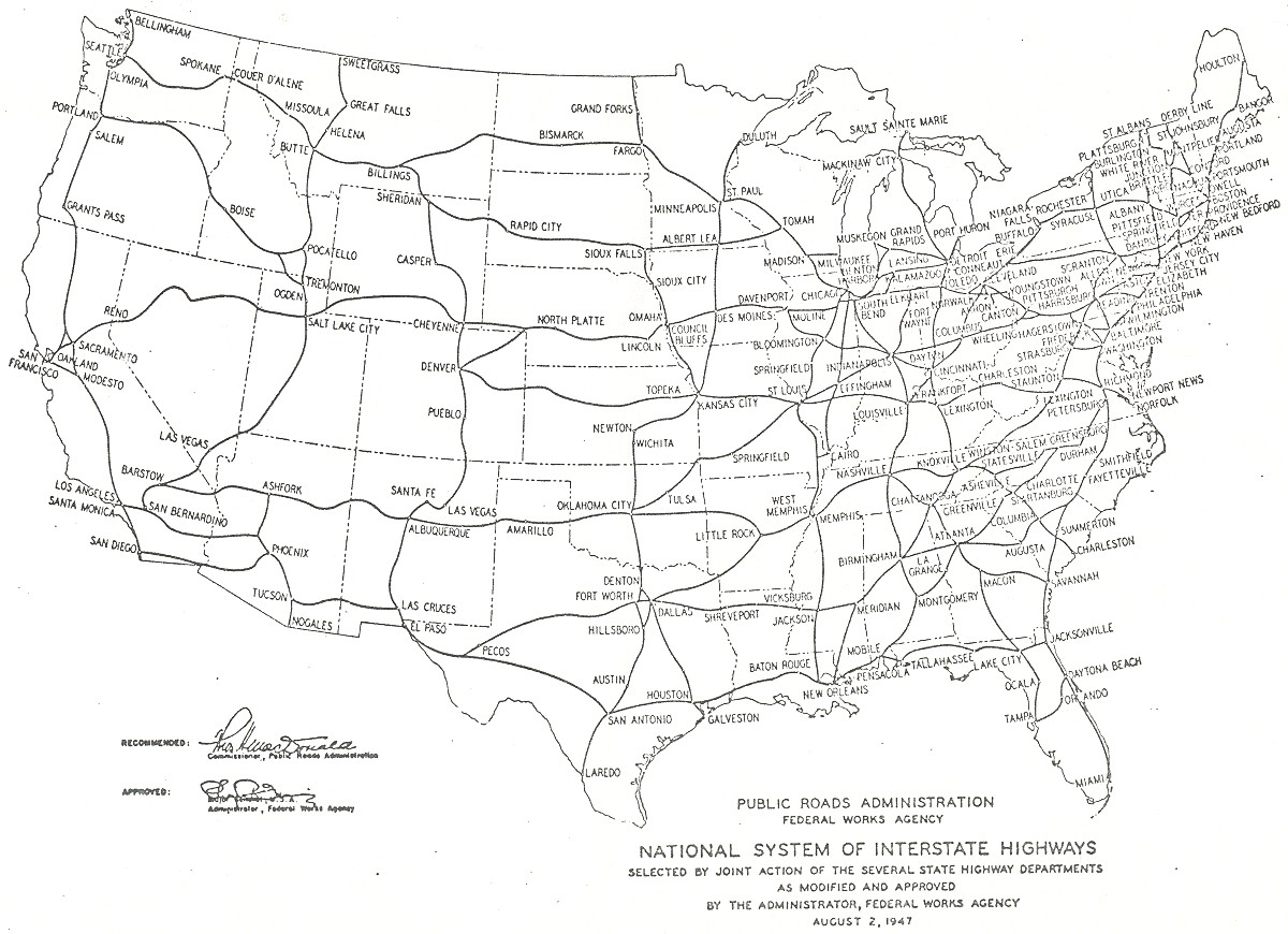
Above is an excerpt from the government’s 1947 plan to build the US Interstates. The map closely approximates the highways as they were actually built years later... with one major exception. This map has no interstate heading west from Denver. It’s not a mistake. In 1947, most highway engineers couldn’t imagine building a freeway west from Denver, because that’s where the Rocky Mountains begin. Back then (and now) roads were built around mountains... or through mountain passes. But west of Denver, the Rockies present a massive wall-like front. An Interstate would be ridiculously expensive and complicated to build. Case closed, right?
Nope. When Colorado lawmakers saw the map, the went apoplectic. To them, extending I-70 west of Denver was a key to economic growth. Mountain highways mean ski resorts, and ski resorts make lots of money. After the tantrum, Colorado’s politicians got their way—I-70 was built, and America got better access to Vail.
(You can see the full 1947 map here and the updated plan here)
Labels:
Fun map stuff
ERA map: Half-Pint vs Scarlett
Do you think women should have the same rights as men? In at least 15 U.S states, the legislature is not so sure. The Equal Rights Amendment is not the law of the land, because more than a dozen state legislatures have voted against it. And this isn’t some complex 5,000-page omnibus proposal. The ERA is just 24 words: “Equality of rights under the law shall not be denied or abridged by the United States or by any State on account of sex.” Back in the 1970s when this was hotly debated, opponents said that passing the ERA would mean unisex bathrooms, and women fighting on the front lines in war. The notion that men and women are not identical (very true last time I checked) got mixed up with question of equal rights. People got scared and the whole thing crashed and burned just 3 states short of approval. Opposition was fiercest in the south, but even Illinois couldn’t find the votes to ratify the amendment.
Creating a map of this debate is revealing. Many of the the traditional red states in the mountain west split from their brethren in the south on this issue. That’s because—historically—westerners have held a slightly different perspective on the role of women. For example, Wyoming was the first state to allow women to vote. Partly, this has to do with an understanding that it took particularly robust women to survive in the harsh conditions of the pioneering west. If you’re a gal who's tough enough to chop the head off a chicken, go months without bathing, and live in a sod house, no one’s going to tell you you can’t vote. Put another way, those Little House on the Prairie girls are a lot more scrappy than Scarlett O’Hara.
Labels:
Fun map stuff
Historian: North Dakota not really a state
In November of 2012, the people of North Dakota will vote to become a US state. This is no joke. It turns out the 122-year-old state constitution has a flaw that no one noticed until historian John Rolczynski caught it in 1995. You can read up on all the details here, but the outcome is that—technically—North Dakota is still a territory; that is, until they vote to fix the problem next year. Since no one has created an updated map of the 49-state America, we figured it was our duty to do so.
Labels:
Fun map stuff,
In the news,
Lost States
America's most "Desperate" state
What state do those "Desperate Housewives" live in? Sharp Lost States reader "A B" pointed out evidence that Wisteria lane is located in the state of "Eagle." See the license plate above--from a surreptitious snapshot taken on the show's set. Where Eagle is on the US map will require a bit of homework (more on that later), but I can say this: be glad you don't live there. The place must have the highest crime rate in the world! Consider the violent crimes committed in just a few years on one block of a fairly well-to-do neighborhood: murder, suicide, arson, kidnapping, vehicular manslaughter, fraud and theft. Oh, and there was a serial killer wandering the neighborhood. And a plane just happened to crash there, too. These people can't even go to the grocery store without a shootout. If you visit the Desperate Housewives set, you'll notice the Leave it to Beaver house just down the street. I don't recall Wally and the Beav ever fighting off serial killers.... my how times have changed in that neighborhood!
Labels:
Fun map stuff
Subscribe to:
Posts (Atom)


