Rick Perry wants to be president.... of what?

North America's 4 biggest nations—according to Rick Perry.
What country does Texas Governor Rick Perry want to be president of? Late last week, he stuck his toe in the presidential waters, but he didn't clarify which country he thought he might want to lead. Remember, in 2009, he said Texas has a right to secede from the United States and form its own country. So is he considering running for president of the United States of America? Or the Nation of Texas?

Rick Perry might be a great potential US president—or not—I don't know. What I do know is that he makes a lot of mistakes about geography and history. For example, we noted before that he seems to think Juarez is in Texas (it's actually in Mexico). Also, while he's correct that Texas has a unique right to split into separate US states, there is nothing anywhere that supports his claim that Texas has a special right to secede from the Union. Creating new states is totally different from seceding... any 6th grader should understand that. America has added new states 37 times. But the US government has never allowed any state to secede. There was a big war over that.

Admittedly, there is a serious school of scholarship that suggests secession should be legal. Thomas Woods makes a compelling case. But even if that's so, Texas has no "special" right to consider secession. It has the same right that Idaho has.

And fast drivers take note... would a Perry presidency mean the whole country gets an 85 mph speed limit... like they have in Texas??

Forgottonia Revisited


Forgottonia seems to be a hot topic these days, so I thought I'd revisit the entry from Lost States:
Illinois has lots of freeways. Lots. But one section of the state got left out--the counties in the western bulge. Largely cut off from the rest of the state by the Illinois River, this area didn’t get any fancy freeways in the Interstate boom of the 1960s and 70s. In protest, a group of residents decided to form their own state, Forgottonia. They appointed a governor and tried to attract attention. But what they really wanted was Interstate 72, which would provide a shortcut between Chicago and Kansas City. The highway legislation that would have built I-72 was defeated in Congress in 1968, and then again in the early 70s. Parts of I-72 were eventually built decades later, but even today I-72 only extends to the Illinois-Missouri border.

And so Forgottonia still struggles. Businesses have steadily left. Amtrak’s arm had to be twisted to ensure continued service. The region even had a college up and move to a different state—which is pretty amazing considering the infrastructure they decided to leave behind. Such is the sad story of Forgottonia. It never had a real shot at statehood—and it’s still pretty much forgotten. But they do have corn. Lots and lots of corn. So as long as America keeps drinking 64-ounce fountain drinks, Forgottonia’s people will survive. About the only thing that could hurt Forgottonia today would be medical reports suggesting high-fructose corn syrup isn’t healthy.
  Oh.

Loring vs Turner - The Feud

The fine folks at Baseball Think Factory have been debating a claim made on these pages... namely whether Loring, Montana is the furthest city (in the lower 48) from a major league baseball ballpark. It seems another site (flipflopflyball.com) made the claim that the honor should got to Turner, Montana. So the crack staff at Lost States checked their facts, double-checked them again, then triple-play checked 'em again. And we're still right: it's Loring.... not Turner. Sorry flipflopflyball.com... you know a lot more about baseball than we do... but we do know our maps. For the record, Turner, Montana is 916 miles to Target field in Minneapolis, which is further than Loring (at 878). HOWEVER, Turner is just 825 miles to Safeco Field, much closer than Loring's 879. So Loring's 878 miles from the nearest ballpark makes it the winner (actually the loser, but...). [For you sticklers, we used road miles as suggested by Google Maps]

Atlanta from "Gone With the Wind"

Gone With the Wind is among the bestselling books of all time. Here at Lost States, we thought it would be fun to see how the story played out on a map. It didn't take long to realize that author Margaret Mitchell used lots of real places in the book—locations than can be pinned down on an 1860s Atlanta map. She even placed her fictional buildings in the neighborhoods where you'd expect them. We were surprised no one had previously collected all this info on a map of Atlanta—so we created the detailed "period" map above.
House #1 is Rhett Butler's residence; # 2 is the Leyden House, and #3 is the Governor's mansion. There's lots more. To see the detail up close, zoom in on the map above.  Better yet, to buy a print go here.  (and you can always used the little "M" icon below to mail this page to your Gone With the Wind-obsesssed Aunt Myrtle. You know, the aunt who named her cat "Rhett.")

Tornado map's weird anomaly

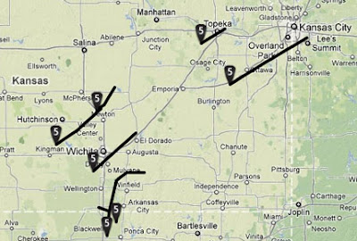
Of course, our prayers go out to the people of Joplin, Missouri and other cities after the devastating tornadoes of recent days. To get a better sense of whether you are in the line of fire of an F5 tornado, check out the very cool maps at the Tornado History Project. You can see the actual paths the worst tornadoes of the past decades—in a zoomable Google map. And here's the weird part: when you look at the map of F5 tornadoes, there is an odd void over Missouri. All the surrounding states have tons of F5s, but Missouri is like a blank spot... as if a forcefield is protecting it from the worst killer twisters. Until two days ago.

Denmark claims North Pole. Is Ecuador next?

This past week Denmark admitted it's planning to stake a claim to the North Pole. That's because the pole has lots of oil and gas, and Denmark wants it. It's a pretty pathetic land grab, given Demark's distance from the pole. Yes, I know Denmark "owns" Greenland, but it's not like any Danes really spend any time on the frozen island. They just want the commodities they can exploit. Of course, the silliness in the region isn't limited to the Danes. The Russians also want the Pole, and in 2007 they sent a little submarine there to plant a tiny Russian flag underwater. No kidding. Canada, the US, and Norway also make tenuous claims to the region—what next? Will the Ecuadorians claim the pole is theirs? Makes about as much sense as Denmark.

Borders from 1967.... is that 1967 A.D. or B.C.?

In his big speech, Pres. Obama forgot to tell us which 1967 borders he wanted for Palestine. Did he mean the borders from 1967 A.D..... or 1967 B.C.? Yesterday's speech was as big as it gets on this type of thing—as Obama proposed nationhood for Palestine. His talk was all about where the borders should be; and we love border-talk here at Lost States! That's why we were so dismayed that the president didn't get specific on the A.D. vs B.C. issue. Sure, the 1967 A.D. borders would mean a 2-state solution, but the Israelis don't much like that idea because the 1967 A.D. borders are difficult to defend. I'd guess the Israelis would like the 1967 B.C. borders even less, since the Canaanites would get most of the region. And one thing both sides can agree on: we don't want the Canaanites back. Given the Canaanites proclivity for child-sacrifice (and other stuff we can't even mention in a family-friendly blog) we can all be glad the Canaanites are gone from the earth.

California's first flag revealed

What the heck was the animal on California's first flag? And who designed this monstrosity? Here's the backstory: In 1846, California was a part of Mexico, not the United States. Nonetheless, a lot of Americans were moving there and the newcomers didn’t much like the idea of Mexican rule. Things were getting tense.

Into the middle of this drama stepped America's top government official in the region—John Fremont. Passing through the Sacramento area in June 1846, Fremont decided it was time for America to take California—and he authorized an overthrow of the Mexican government. In reality, Mexico had very few resources  in California, and the takeover required little more than knocking on the door of Mexican General Mariano Vallejo, and asking him to surrender. Vallejo was enthusiastic about the idea. He offered everyone a round of brandy--and asked the Americans if he could join them. Fremont responded by putting Vallejo in jail at Sutter’s Fort.

Conquerors like to raise flags, and Fremont and his associates were no exception (See above). The animal in the middle that resembles a pig--is actually a bear. Thus this victory came to be called the Bear Flag Revolt. The man who designed the flag was William Todd—the nephew of Abraham Lincoln. It's not clear how Todd got the job, since his artistic ability seems indistinguishable from that of a 2nd grader. Nonetheless, a bear remains on the California flag to this day.... although more-gifted artists have since re-imagined a bear that looks more, well... bear-like.

It's worth noting that the original Bear Flag was destroyed, but accurate sketches and other documentation were gathered to create our reproduction. You can see a bigger version of our flag here. (Updated. Thanks Judah!)


Backwards time (zone) travel

There are a few spots in the US where time travels backwards—sort of. Let me explain. In most places, when you travel eastward from one time zone to another, it gets an hour later. That's just how time zones work. But there are a few odd spots where traveling eastward means setting your watch an hour earlier. And this has nothing to do with Daylight Savings Time. Instead, it results from the bizarre twists and turns of time zone boundaries. In the example above, Paulding, Michigan sits in a little notch in the Eastern Time Zone. So if you travel due east from Paulding, you enter the Central Time Zone—which is an hour earlier. Weird! There are several spots like this, many nicely documented by a site called 12 Mile Circle. What's the value of this tidbit of arcane knowledge? Well, it might help you win a bar bet or two. More importantly, it illustrates that time zone boundaries reflect a patchwork of local politics that don't always make a lot of sense in the big picture. 

Earliest fireworks - solving the sunset problem

(Updated. Thanks q) What place in America has the earliest sunset—local time? This is a really important question for the upcoming 4th of July; because an earlier sunset means earlier fireworks fun! Who can stay up for fireworks that start at 11:00pm? Zzzzz. As America ages (and gets tired earlier), we need to look for places with the earliest possible sunsets. But where in America does the sun set the earliest? (according to local time, that is)

This was a much harder question to answer than I originally expected. In Alaska and Hawaii, you just go to the easternmost point—easy. But in the rest of the nation, it's way more complicated. That's because the easternmost point of a time zone is not necessarily the place where the sun sets the earliest. Remember, in midsummer, the days are really long in the far north, and get gradually shorter as you move south. So you need an algorithm to figure this out. Or you can just check a lot of places—that's what I did. (Ironically, the best site to find sunset times for your Independence day pyrotechnics.... is run by the British.)

The winner is Sneads, Florida, with a 7:47 sunset on July 4th. However, if you live in the northeast and can't make it to Sneads, Quoddy Head State Park in Hogwarts Maine will have to suffice, with a 8:17 sunset. Folks in the mountain region will have to settle for Syracuse, Kansas with an 8:13 mark. Californians can do a little better by driving out to Parker Dam and a 7:53 sunset. Of course, I'm not a professional sunsetologist. If you have better information, please add your comments.

Canada's split: NY Times

Most Canadians don't consider Vancouver to be a part of the "real" Canada—that's according to a recent New York Times article.  The Times illustration goes like this: with the Vancouver Canucks as the only remaining Canadian team in the National Hockey League finals, you'd think all of Canada's citizens would be rooting for their countrymen to defeat the 3 American teams—right? Not so much. The Times says Canadians consider Vancouver "foreign." That may seem odd... then again, it is the only major city in Canada that never gets snow. And Vancouver is geographically closer to Russia than it is to Montreal. In fact, some parts of British Columbia are actually closer to Japan than to easternmost Canada. So if the prestigious New York Times suggests many Canadians want to kick Vancouver (and all of BC, I presume) out of Canada, well... that needs a map. Behold the new country of Canucka.

Samoan Time Warp

It's like something out of the TV show "Lost." A madman on an island in the south Pacific has found a way to jump forward in time. It's true.... but maybe not quite that dramatic. The "madman" isn't really all that mad, just a little eccentric. And all he really wants to do is move the International Date Line. Wait, you can do that? Indeed you can. The leader of the nation of Samoa, Tuilaepa Sailele Malielegaoi, wants to switch to the west side of the Date Line, so his country will be in sync with Australia and New Zealand. Most Samoans think he's nuts. This is the same guy who declared that all Samoans had to switch from driving on the right side of roads to driving on the left. I'm not making this up. At least neighboring American Samoa is staying sane. No time zone switch proposed there. But if you travel from the Nation of Samoa to American Samoa--just a few miles apart--you will switch days every time. Hmmmm.... what if you took a really fast jet and flew in circles from one to the other over and over.....  (Press reports here and here and here)

Saddest town in baseball

Quiz question: What US city (in the lower 48) is furthest from a major league baseball team? The crack staff at Lost States spent way too much time figuring this out. It's Loring, Montana--nearly 900 miles to the nearest ballpark. So if major league baseball wants to correct this geographic shortcoming, it should start an expansion franchise in Loring. But what to call the team? What's Loring famous for? It's hard to know; even Google and Yahoo searches reveal nothing other than automated links like "nearest singles to Loring, Montana" or "nearest day spas to Loring, Montana." (I bet no one's ever clicked on that one!) Hmmm, maybe the team's name should reflect this search engine shortcoming—call the team the Loring Yahoos. Are you listening, Bud Selig? (5/26/11 UPDATE: We fend off claims that Turner, Montana is sadder than Loring.)

Baja Arizona map

Reports on the proposed 51st state of Baja Arizona are heating up, but no one seems to have a clear, simple map of this idea. So I made one. There is a larger version at flickr that you're free to use in your blog, newspaper etc. Wire service Reuters has a mapless story today—as does The Atlantic. How can they have a story about a new state--and not have a map?! Sigh.

NPR reports on 51st state story

The proposed 51st state of Baja, Arizona made the news on NPR today. Of course, we here at Lost States have been all over this movement for a while—with our first story months ago... a piece making the connection to the Gadsden purchase.... our genius idea for an extended state... and a report on the problem of naming the new state.  And you can read about Baja Arizona (and see a cool map) in the book Lost States.  Oh, here's the NPR story. 

Mysterious island - an evil lair, or??

Bouvet Island in 1898
No that Osama is gone, are there any evil masterminds left? Anyone who might be James Bond-worthy? In fiction, these arch-criminals plot world domination from a lair on some uncharted island.  But that's all fiction, right? Consider this true story: At 00:53 GMT on Sept 22, 1979, the American Vela satellite detected the signature of a nuclear detonation on Bouvet Island, an uninhabited rock in the south Indian ocean. To this day, no one knows who was behind the explosion.

President Carter was so alarmed, he called his advisors to the situation room. They didn’t have any answers. Subsequent investigations suggest the explosive device may have been a neutron bomb, a tactical nuclear device that kills people, but leaves structures largely intact. Some investigators think the South African government was behind the detonation, others speculate it was Israel, France, or maybe Taiwan—but evidence for any of these options is scant.

Bouvet is the most remote island on earth. While Norway claims it, there are no known residents. In 1964, a passing ship found an abandoned lifeboat on the island, filled with supplies. No one knows how it got there. Admittedly, it’s a bit of a stretch to suggest the island is the secret base of of a real-life Dr. No. But one thing is for sure. Something very scary happened on Bouvet Island. And we don’t know who did it.

Splitting up Canada?

The only places the separatists won a majority in Monday's election
The platform of the Bloc Québécois (BQ) party involves seceding from Canada to form the new nation of Quebec. How did they do in Monday's election? Not too good. But let's step back a moment... they had an election in Canada on Monday?  Who knew? Yeah, Americans are blissfully unaware of this stuff. The only Canadian prime minister Americans can remember is Pierre Trudeau—and that's only because his beautiful wife Margaret was an iconic jet-setter, partying with the likes of Mick Jagger. Anyway, back to the election. The Bloc Québécois got pummeled, garnering just 6 percent of the vote. It's a long way from their heyday in the mid-90s, when Quebec came within a few thousand votes of splitting from Canada. (That story is detailed in Lost States)

Panetta: New York City should be 51st state

Leon Panetta was a major proponent of statehood for New York City, according to a long-forgetten report he wrote for mayor John Lindsay.  It's significant, since Panetta is about to be confirmed as the new Secretary of Defense—among the more powerful jobs on earth.  As a staffer for mayor Lindsay in 1971, Panetta wrote that making New York City the 51st state, "... may well be the only sensible approach to governing New York City." Panetta's reasons fit the usual profile for new statehood proposals—he thought the rural legislators (read "bumpkins") were standing in the way of New York City handling its own affairs. The thing that struck me as I read the full report was how Panetta thought the best model for governing New York City was London. Yeah, London, England. Didn't we fight a war so we could avoid the British model of governing? In summary, the soon-to-be Secretary of Defense is on record saying the British system of governing is superior to the American system. You heard it here first. I wonder if that comes up at his hearings. Read Panetta's full report here.  (More on New York City statehood is in Lost States)

Osama map hijinks

So if you zoom in on Abbotabad in Google maps, you can see the closest restaurant to Osama's house... probably the place he called for takeout. It's the "Red Onion" (what you were expecting Olive Garden?). In the last day or so, "reviewers" have been having a lot of fun posting comments—like Chad who says: The foie gras is to die for, but the ambiance when I went was ruined by the constant noise of helicopters. Then there is the comment from Osama Bin Laden himself: Love that bloomin' onion appetizer but it goes straight to my thighs. Normally I'm against map defacing, but the comments are pretty funny. Read 'em all here.

How the States got their Shapes

So you enjoyed the May 3rd premiere of the new History Channel series entitled How the States Got their Shapes hosted by Brian Unger. And now you want the full-color book (great for Father's Day!) that tells the strange and funny stories of American geography. You're in luck! Lost States is now 35 percent off at Amazon. 

Congress says Hawaii's not a state--in 1993

I hate to give birthers a Plan B, but I've stumbled upon a conspiracy theory that is just too juicy to ignore.  Specifically, Barack Obama can't be the legal president, because Hawaii is an independent kingdom, not a US state—a fact that the US Congress affirmed in 1993. Stay with me—let me connect the dots: In 1993, President Bill Clinton signed the "Apology Resolution," a document that stated quite clearly that the United States illegally conspired to overthrow and take over the independent nation of Hawaii in 1893. The document says:
"The Congress: apologizes to Native Hawaiians on behalf of the people of the United States for the overthrow of the Kingdom of Hawaii on January 17, 1893... and the deprivation of the rights of Native Hawaiians to self-determination... and urges the President of the United States to also acknowledge the ramifications of the overthrow of the Kingdom of Hawaii."
Congress voted in favor of this and Bill Clinton signed it into law. Senator Slade Gorton (R-Washington) refused to vote for the measure, saying, "...the logical consequences of this resolution would be independence." Let's just assume Slade (what a great first name!) was correct. In that case, the US government gave Hawaii its independence in 1993, which means it's not a US state—which means Barack Obama can't be the president. OK, I admit it's a desperate, contorted stretch to make a conspiracy out of nothing—but that's why it's perfect fodder for the birthers.


Bin Laden's 2001 escape... the "X"s and "O"s

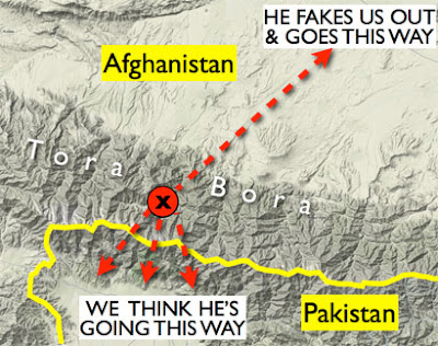
Why did it take 10 years to get Osama Bin Laden? Think football. In December 2001, Bin Laden ran an end-around misdirection play, faking out his pursuers. At least that's how Guantanamo detainee Harun Shirzad al-Afghani tells the story in fresh Wiki-leaks documents. Remember, Bin Laden was pinned down behind the line of scrimmage in Tora Bora in late 2001. The American military called an all out blitz. But Bin Laden did a Favre-like escape. Most assumed he slipped south across the border into Pakistan. But since that's what everyone expected, Bin Laden apparently reversed field and fled north. Sure, the American military was caught flat-footed in that play... but kudos on the 4th quarter comeback yesterday, boys! The real America's Team gave 110% in a sudden death overtime. (Read about the 2001 escape here)