Forgotten secession: when the original 13 tried to split.

In 1812-13 there was a movement in the original thirteen states to secede from the rest of the nation—an idea first championed by a guy named John Lowell of Massachusetts. You have to admit there was some logic to this. As the United States expanded, the original 13 states had less and less influence. Even a third grader can do the math: in the late 1700s, the two Massachusetts senators made up nearly 8 percent of the US Senate. Today, it's just 2 percent. Lowell thought his state had less and less control of its own affairs, so he advocated expelling the western states from the Union. The governors of both New York and Maryland liked the idea. Lowell laid out his argument in a tract with the less-than-snappy title: Thoughts in a series of letters, in answer to a question respecting the division of the states. By a Massachusetts farmer. The idea was popular in certain influential circles, but eventually it died out. Maybe if Lowell had come up with a more catchy title... like "Think Small." You can read more about it  here  or read all of Lowell's original tract here.

Italian guy creates his own nation

Italy has always been a land of micronations, city-states, and enclaves. Even today, San Marino and Vatican City are tiny independent nations surrounded by Italian soil. So why not one more? That's the idea of Luca Sellari, the new mayor of the Italian city of Fillettino. When the Italian government decided to save money by forcing towns of less than 1,000 to merge with neighboring cities—that was enough to hatch Sellari's plan. He wants to make Fillettino (pop. 598) an independent kingdom. And who will be the monarch? Sellari thinks he'd do the job just fine. He even started printing up money with his face on it.

Sellari isn't the only mayor in Italy trying to save his city from annexation. Some towns on the bubble are inviting displaced Libyans to come and live. Others have pointed out that the cost savings of merging the small cities is actually less than the Italian Parliament spends on catering. It's not likely Fillettino will succeed, but politics in Italy has never been predictable. (You can read more here.)

Worst geography blunder in a movie?

What movie has the worst geography error? Steven Seagal's Submerged is is classic—portraying Uruguay as mountainous (it's actually flatter than Kansas). Then there's the goof in Armageddon, where people all over the earth simultaneously celebrate the asteroid exploding—but it's not nighttime anywhere (That's a Michael Bay movie... he is notorious for this stuff). And there's Indiana Jones and the Kingdom of the Crystal Skull which consistently confuses Mexico and Peru. But my personal favorite is the 1969 disaster movie Krakatoa, East of Java that actually won an Academy Award. The problem: Krakatoa is west of Java. Ooops. (More movie geography errors here)

The Rodney Dangerfield nation

"I don't get no respect" ...that was the catchphrase of comedian Rodney Dangerfield. And it might as well be the slogan of the new nation of South Sudan. 48 days after independence... and it's still not on Google Maps. These things take time, you might think. Not really. When rebel forces took control of Tripoli this week, Google changed names on its Libya map within hours. Yes, hours. But South Sudan is still waiting.  There's an excellent article about all this at Mashable. Maybe South Sudan should just change it's name to South Dangerfield. At least then it would get some attention.

Obama's secession secret?

There's been a lot of criticism of Rick Perry's talk of Texas secession, but at least he's not giving his vacation dollars to a government that recently voted to secede—like President Obama is. OK, it's a stretch, I admit... but it is kind of funny that Obama is vacationing on Martha's Vineyard—one of the only places in the north that actually voted in favor of secession. And it wasn't centuries ago... it was 1977. The people of Martha's Vineyard and Nantucket were so mad at Massachusetts, they actually voted to leave the state. There was some talk of forming a new country, but most of the proposals had Nantucket and Martha's Vineyard joining Vermont. Or perhaps Hawaii. Yeah, Hawaii offered an invitation. Wait a minute, that's where Obama's from! Conspiracy theorists, start your engines!

OK, nobody actually believes that President Obama sides with Martha's Vinyard's lingering secessionists.  So if secession came up, on say, a political talk show, I'd expect Obama's spokespeople to deny any silly secessionist talk. Wait a second! Obama's campaign advisor Robert Gibbs can't seem to stop talking about secession! And press secretary Jay Carney is no better.  Yes, I know they are poking at Perry, but it strikes me as odd to point the "He's a secessionist" finger when their man is actually staying on Secession Island.

Criminal Corner - Another spot for the perfect crime?

Yesterday we laid out the case made by legal scholar Brian Kalt that major crimes committed in the Idaho portion of Yellowstone National Park can not be prosecuted because of a legal loophole. Reader DanV wisely wondered why the same situation wouldn't also apply to the Montana portion of the park.

It does, sort of. Remember, the reason criminals would go free in Loophole Land is because a jury could not be formed from residents of the required location (the Idaho portion of the park) because no one lives there. But the Montana portion of the park does have residents... about 40 of them. That said, a sharp lawyer could argue that 40 people isn't enough of a pool from which to draw a jury, but a judge could reasonably disagree.

But if your heart is set on committing the perfect crime in Montana's "Criminal Corner" you do have one other option—get your buddies to do the same thing. While 40 residents might be enough for one jury, it wouldn't be enough for 3 or 4 simultaneous trials. So if you and your friends commit multiple crimes... and draw straws... only the loser would likely face a trial. That's because—by the time the 3rd or 4th trial could be scheduled—too much time would have passed for the "speedy" trial required by law.

But again, don't try this at home. Crime is bad. Prof. Kalt agrees... he just wants the loophole closed.

Loophole land—where crimes can't be prosecuted. Really.

According to a law professor from Michigan, there is small section if Idaho where major crimes can not be prosecuted—thanks to a giant blunder by Congress.

The problem begins with the boundaries of Yellowstone National Park. Yellowstone is mostly in Wyoming, but a sliver of the park extends into Idaho and Montana. When Congress created the U.S. District Court of Wyoming it included all of Yellowstone National Park. Big mistake.

Stay with me here.... so let's say you commit a murder in the portion of Idaho that's in the park (The red "Loophole Land" on my map). You'd be arrested and bound over for trial in the US District court in Cheyenne, Wyoming. But Article III of the Constitution states that the trial must be held in the state where the crime was committed—in this case Idaho. So you are sent to Idaho for trial. No problem there. But the Sixth Amendment also says that the jury must be drawn from the state and District where the crime was committed. The state is Idaho... but the District is the Wyoming District (which includes the sliver of Idaho that's in the park). So the jury would have to be drawn from residents who live in the portion of Idaho that lies in the park.

And that's where it gets interesting: nobody lives in that patch of Idaho. Nobody. No jury pool means no trial, means you go free.

This curious loophole was discovered by Prof. Brian C. Kalt, a respected legal scholar from Michigan State University. Georgetown Law Journal is reporting on the matter in an upcoming issue. (You can read Kalt's full article here)

Of course, committing crimes is bad. Don't do it. But if you're a screenwriter, this is great stuff! Maybe Dick Wolf will start a new series Law and Order: Idaho just to take advantage of this legal anomaly.

And if all this wasn't bizarre enough, Idaho's "Loophole Land" is just a few steps from another patch of American soil that also fell outside the law. Dubbed "Lost Dakota" it was a few acres of land that—erroneously—were not part of any state and thus, theoretically, outside the reach of law enforcement. (Much more on this in my book Lost States) Eventually that situation was fixed when Lost Dakota became a part of Montana. But Loophole Land remains an unsettling, well, loophole. If your nemesis suggests a camping trip near the Idaho/Wyoming border.... don't go!!!

When Hawaii was Russian

Hawaii became a U.S. state 52 years ago yesterday. One long-forgotten chapter in Hawaii's history is when the Russians tried to take control of the islands. Back in the early 1800s, Hawaii was a coveted port for whalers. So, in 1816, the Russians began building a fort on Oahu, hoping to control the islands. King Kamehameha I would have none of it, and forced them off the island without any bloodshed. But the Russians didn't go home. Instead, they tried to build their fort on nearby Kauai. When Kamehameha found out, he took more severe action—deporting the Russians to California. This ended Russia's plans in Hawaii, opening the door for the United States a few decades later.

(There's a terrific article about the statehood struggle of Hawaii (and the possibility of a 51st state) in yesterday's Buffalo News—written by Alexander Heffner.)

The place that's name shall not be spoken

I'm not going to write the name of this place, because I fear Google will put up some weird ads. Hey, this is a family-friendly site! Still, it's a real place in Macon County, Georgia—between Mooney Gap and Bearpen Gap. You have to admit that it's kind of funny that there is a place with that name. If fact there are several. The term means an "abrupt, broken off end of a ridge or mountain." OK, sure. Your can read about this and other odd place names here.

The Northwestern Confederacy

Secession-talkers like Rick Perry get a lot of heat these days, but the truth is, America has always had leaders who advocated leaving the Union. And I don't just mean in the Civil War era. There were secessionists at the very beginning—and we still have them today. We'll look at several of these stories in the coming weeks.

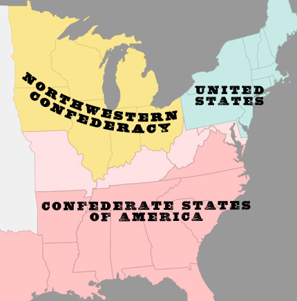
Above is a map of a little known secessionist chapter in American history, called the Northwestern Confederacy. Southerners hoped the northwestern states (which then was Ohio, Indiana, Michigan, Wisconsin, Minnesota, Illinois and Iowa) might also secede from the United States and form their own nation; or join with the south. There was actually a very practical reason for the northwestern states to do this. Many of their goods traveled down the Mississippi to market. Since the Confederacy controlled the southern half of the river, the Northwest needed good relations with the south in order to avoid economic hardship.

The idea was centered in Indiana, where even governor Thomas Hendricks said in 1862, "The first and highest interest of the Northwest is in the restoration and preservation of the Union but if the failure and folly and wickedness of the party in power render a Union impossible then the mighty Northwest must take care of herself and her own interests." So the idea of a Northwestern Confederacy had the support of many farmers—but they weren't alone. The northwest also had its share slavery proponents, and people who just wanted to end the war any way possible. Certainly, the creation of a Northwest Confederacy would have weakened the north and almost certainly ended the war.

Then again, the idea was considered treasonous.... which may be the main reason support didn't grow to any sort of tipping point.

Is Kansas flatter than a pancake?

Scientists at Arizona State and Texas State have focused considerable research energy on one of the great questions of our time: Is Kansas really flatter than a pancake? Of course, they used the standard measure of flatness: The length of an ellipse’s semi-major axis A is compared with its measured semi-minor axis B using the formula for flattening, f = (a – b) / a.  Of course.

Using a standard IHOP pancake, the team calculated a flatness of .957, which is flat, but shy of perfect flatness (which would be a 1.0). Applying the same formula to the topography of Kansas, the scientists came up with .9997, which is much much flatter than a pancake. So it's not really right to drive through Kansas and say, "This place is as flat as a pancake." However, if you ever went to IHOP and got a particularly flat pancake, you would be OK in saying, "This pancake is a flat as Kansas."

Thank university scientists by Mark Fonstad, William Pugatch, and Brandon Vogt, for solving this vexing question.

Snooki vs Montana

No one is likely to be surprised that Snooki from Jersey Shore is a bit of a dim bulb. But her geographic illiteracy was on full display last week when she was interviewed by a Montana radio station. Snooki asked, "Where is Montana? Is that a state?"

That gives me an idea for next season... send Snooki and company to Montana... let 'em work on a ranch... get bucked off a bronco... step in buffalo dung. Now that would be entertaining.

Rick Perry and Texas secession revisited

Can Texas secede from the Union, as presidential candidate Rick Perry once suggested? Probably not. Can Texas split into multiple states pretty much whenever it wants? Yes, absolutely—and, most Texans of the 19th century assumed this would happen. The question was not "if," but "when" and "how." There were multiple plans introduced into the Texas legislature over the years, some for two Texases (or is it Texi?), others for three or four. One proposal that got introduced multiple times is shown in the  map above. In its most-recent iteration (1870) it was called the Beaman plan and divided Texas in three: Jefferson in the east, Matagorda in the west and Texas in the middle. The proposal didn't get enough votes, but Texans kept trying. (Several of the plans are described—with maps—in Lost States)

Now that Rick Perry is officially in the presidential race, I wish he'd clarify his statement about secession. He might be a great potential president; he might be a lousy one—I have no way of knowing. But I do know that the jury is still out on his command of American history and geography. The right to split into multiple states is explicitly true for Texas, although it's also true for any state. While Texas has never split, Massachusetts has—creating Maine. Virginia also split, creating West Virginia.

But the topic of secession (that is, leaving the US)  is more tricky. The last time any state tried it, a civil war was triggered, and we all know how that turned out. That said, historians and scholars like Thomas Woods point out that secession isn't actually unconstitutional. The whole thing is a lot more nuanced than you learned in elementary school. Rick Perry might actually have a command of this stuff... or he might have it all wrong. It's not clear just yet which one that is.

Kanawha - the rough draft of West Virginia

Before West Virginia was, well, "West Virginia," it was "Kanawha." That was the original name for a proposed state that would split from Virginia. The idea actually dates back to long before the Civil War. And the reason is crystal clear on this historic map. Darker-shaded counties have more slaves, lighter counties have fewer. You can see at a glance that the people of western Virginia had fewer slaves, and thus were much less interest in preserving the institution of slavery. When statehood finally came to pass, the shape of the new state was pretty close to the plan of Kanawha.  What I can't figure out, however, is why the "N" in Kanawha is backward.

Garden of Eden - located!

Has the Garden of Eden been located? New scientific research, coupled with coordinates laid out in the Bible itself, mean it may indeed be possible to determine the garden's location on a modern map. This shouldn't be all that surprising of a development. Archeology consistently validates the historicity of  Biblical geography. Even non-believing archeologists recognize that the Bible describes real places.  (For lots more on this, here's a great article by my favorite author Paul L. Maier)

But what about the Garden of Eden? Most Christians believe it was a real place, but unlike Jerusalem or Rome, its ancient location is not obvious. Yet the Bible does offer a surprisingly detailed description of the Garden of Eden's location. The problem has always been that that researchers could not find two of the rivers mentioned in the Biblical description. Modern hydrological sciences have recently solved that problem, giving scientists all the data necessary to triangluate the Garden of Eden.

But the data didn't add up. Until recently, that is—when Phd hydrologist Ward Sanford offered an elegant solution. You can read his full report here (scroll down for the details). But first, watch our video above to find out where the Garden of Eden likely was (or is).


National Geographic's map fail

The National Geographic Society should know better. I've always been a little frustrated that their yellow-bordered National Geographic magazine seems to focus more on sharks and bears—and less on actual geography. Today, for example, their home page features robots playing soccer. How is that geography, exactly? I mean, if they had a real focus on maps and geography, they never would have  used the photo above to promote their "National Geographic World Championship."(It's kind of like a geography bee).  Of course, no disrespect to Pranav Bhandarkar, Stefan Petrovic´, or Anthony Cheng who are all admirable young participants.  The issue is the map. Regular readers will see the blunder right away. Here's a hint: the World Championship took place just a few days ago... in late July.

Swim from Cuba to US ends

This morning, Diana Nyad had to end her quest to swim the 103 miles from Cuba to the United States. She made it half way, which is nothing to sneeze at. Still, what was Nyad trying to prove? She claims the purpose of the swim was to demonstrate the youthfulness of people in the 60+ age group. I guess. But don't we already know that? Two words: Helen Mirren.

I think the bigger point to make here is just how ridiculously close Cuba is to the United States. Given its strategic position, Cuba has been considered for statehood more than once in US history. In fact, the only reason Cuba isn't a state right now is because the U.S. Congress of the early 1900s objected to giving citizenship to millions of people of color.  Fighting prejudice—maybe that's the topic Nyad can highlight in her next try. (More on Cuba's almost-statehood in Lost States)


Tennis pro fails geography

When tennis pro Bojana Jovanovski landed in Carlsbad, New Mexico for the Mercury Insurance Open last week, everything seemed fine—until she realized she was in the wrong Carlsbad. The tournament was in Carlsbad, California. Oops. If only her travel planner had a paid a bit more attention in geography class, she wouldn't have made the 1,000 mile blunder. Jovanovski did eventually get to her match in California... with just minutes to spare. She lost. Hopefully, her next stop won't be Wimbledon Boulevard in Columbus, Ohio.  (You can read more about Jovanovski's Carlsbad experience here.)

Columbus stamp goof - revealed

Yesterday we posed the question: What's the geography goof on the 1993 Columbus stamp? I must say I had the same question as reader Phil, who wondered about possible lines of latitude and longitude on the map that's laying in front of Isabella. So I blew up the image (upper left), revealing that the lines are not parallel, so that's not really a mistake. At least I don't think so. And, like reader Enigma149, I did see Florida on the map—which Columbus would not have known. But, in fairness, that's probably more of Rorschach blot.

The big error, (as readers Ken, tkrausse, and kzimman noted) was the globe. Yes, most smart people in 1492 knew the world was round, but there was just one globe in existence (as far as historians can tell), and it never left Germany. And that globe wasn't a tabletop model—it was a much bigger, floor-standing unit. So that's the most serious error in the stamp above. But there is one more thing... as best we know, Columbus was 41 when he made the pitch to Isabella. Does the guy in the stamp look 41 to you? That's the same age Vince Vaughn is now... and Jack Black. Ah, there's a high-concept movie idea: Jack Black as Christopher Columbus.

US stamp's Columbus error

This 1992 US stamp has a significant geography goof. It's supposed to show Columbus pitching Isabella on the idea of a westward journey across the Atlantic. But one thing in this scene is all wrong. By the time historians caught it, the stamp was already in circulation—and it was never changed. To view it more closely, I've posted a much bigger version here. Take your guesses... the answer tomorrow!

Naming rights for Tennessee

Should the state of Tennessee sell naming rights as a way to make money? The idea was floated the other day by Knoxville humorist Scott McNutt. Of course, McNutt was making a joke, but one major city actually did sell off naming rights to large corporation. And it retains the company name to this day. (More on this here and here.) Anyway, McNutt suggested selling Tennessee's naming rights to Pilot/Flying J... but I think that one of Tennessee's bigger employers would be a more natural fit. How about "Fedexessee"? It kind of rolls off the tongue nicely. Of course, the state flag would have to be updated to purple and orange.  Got a better idea? Add your suggestions.

Ironic Grant County

Grant County, Oregon voted to declare itself a "United Nations-Free Zone" over concerns that the UN has plans to send in the black helicopter fleet, confiscate everyone's guns, and and enslave the local children (oh, wait, that last part's from TNT's new series Falling Skies). The fact that Grant county wants to separate itself from the rest of the USA isn't all that unusual, but it seems that no one there gets the irony. You see, Grant county is named for Ulysses S. Grant. 150 years ago, when another group of citizens didn't like what the government was doing, Ulysses Grant led the army that put a stop to the uprising. It's kinda like Bourbon county, Kansas—where bourbon is illegal. It's funny... and the irony makes it hard to take them too seriously. So maybe the first step Grant County should take is to change its name.... maybe rename itself after some famous statesman who was against the United Nations. I can see the sign now, "Welcome to Charles de Gaulle county, Oregon." 
(Read more about Grant county's anti-UN ways in this article by Jason Plautz)

The unfriendly place?

Above is an unretouched detail from a very popular map... can you guess what place this is? Note the politically incorrect "Unfriendly Indian" village... a settler's cabin that's been set on fire (presumably by the unfriendly Indians); even arrows sticking out of the cabin, from the Indians' attempt to kill the settlers. Still don't know where this is? Here's a hint. You've probably been there. I was—at age 7—just five years after this map was created. (For the answer, see the full map here.)