The map that made Colorado angry

Above is an excerpt from the government’s 1947 plan to build the US Interstates. The map closely approximates the highways as they were actually built years later... with one major exception. This map has no interstate heading west from Denver. It’s not a mistake. In 1947, most highway engineers couldn’t imagine building a freeway west from Denver, because that’s where the Rocky Mountains begin. Back then (and now) roads were built around mountains... or through mountain passes. But west of Denver, the Rockies present a massive wall-like front. An Interstate would be ridiculously expensive and complicated to build. Case closed, right? 

Nope. When Colorado lawmakers saw the map, the went apoplectic. To them, extending I-70 west of Denver was a key to economic growth. Mountain highways mean ski resorts, and ski resorts make lots of money. After the tantrum, Colorado’s politicians got their way—I-70 was built, and America got better access to Vail.
(You can see the full 1947 map here and the updated plan here)

Wayward Mountain Lion - route revealed

Have you heard about this wayward mountain lion that supposedly wandered from the Black Hills to Connecticut? I have a hard time buying this story, but scientists say tracking data proves it. One thing is sure: his actual route remains a mystery. Did this big kitty go through Canada as some scientists believe? Maybe. But why? There's not much up there for the feline tourist.  I think maybe he was on a quest to visit his kittycat friends... the Detroit Lions and Tigers... the Cincinnati Bengals... and the Carolina Panthers. (mercifully, I stopped trying to come up with sports teams named after cats, but feel free to add your own)

ERA map: Half-Pint vs Scarlett

Do you think women should have the same rights as men? In at least 15 U.S states, the legislature is not so sure. The Equal Rights Amendment is not the law of the land, because more than a dozen state legislatures have voted against it. And this isn’t some complex 5,000-page omnibus proposal. The ERA is just 24 words: “Equality of rights under the law shall not be denied or abridged by the United States or by any State on account of sex.” Back in the 1970s when this was hotly debated, opponents said that passing the ERA would mean unisex bathrooms, and women fighting on the front lines in war. The notion that men and women are not identical (very true last time I checked) got mixed up with question of equal rights. People got scared and the whole thing crashed and burned just 3 states short of approval. Opposition was fiercest in the south, but even Illinois couldn’t find the votes to ratify the amendment.

Creating a map of this debate is revealing. Many of the the traditional red states in the mountain west split from their brethren in the south on this issue. That’s because—historically—westerners have held a slightly different perspective on the role of women. For example, Wyoming was the first state to allow women to vote. Partly, this has to do with an understanding that it took particularly robust women to survive in the harsh conditions of the pioneering west. If you’re a gal who's tough enough to chop the head off a chicken, go months without bathing, and live in a sod house, no one’s going to tell you you can’t vote. Put another way, those Little House on the Prairie girls are a lot more scrappy than Scarlett O’Hara.

West North Carolina... or Griffith

Are you ready for the new state of West North Carolina? Yesterday Ashville Citizen-Times columnist John Boyle officially launched the movement to make a new state from counties in western North Carolina. His reasons are the usual stuff—people in the faraway capital just don't seem to care about the hinterlands. Boyle waxed eloquently, "I say we yearn to be free, to shuck the yoke of oppression that Raleigh has kept clamped on our necks for two centuries." That's all fine and good, but here at Lost States, we say you don't have a movement until you have a map! So we took Boyle's description and made one (above). Boyle's next hurdle, (as regular readers know) is to come up with a catchy name. "West North Carolina" is a mouthful. He could take inspiration from the nearby State of Franklin proposal that almost succeeded 200+ years ago, just across the border from Asheville (in what is now Tennessee). Last time I checked, we still don't have a state named "Franklin," so that could work.  Or if the new state really wants to get attention, they should honor the region's most-famous son: Andy Griffith. The 51st state of "Griffith"...now there's an idea that will get attention.

51st state of "West Arizona" or ??

The attempt to split California to create the 51st state has big hurdle—the movement needs to come up with a better name. "South California" won't work, because, well, it not southern Cal. (If you don't have Los Angeles, you can't really be South California.) In an earlier post we suggested "Republicania,"and it seems we are not the only ones mulling this conundrum. Andrew Malcolm at the Los Angeles Times offered a number of choices recently, including New California, English Mexico, and Newer Mexico. Our personal preference was his suggested "West Arizona." After all, the people proposing the split have a lot in common with the prevailing politics in (East) Arizona.  Let us know what you think the new state should be named!

MIT study weighs in on the California split

MIT did a study which tries to identify natural geographic connections by looking at who we text and call. Quoting the MIT release, "in some cases, connectedness follows traditional demarcations such as state lines -- but in other cases, new patterns are emerging." There are all kinds of ramifications, and you can read the details here. The thing that struck me was the three-California split that the MIT study suggests makes sense. It's a lot different from Jeff Stone's recent proposal. And it's markedly different from Assemblyman Stan Statham's 3-state proposal in 1992. For example, Statham puts San Francisco in Central California, but MIT puts the city in the north.

The thing that's cool about the MIT study it that it's based on real people's daily lives. It shows who we are actually connected to, not who we say we are connected to. And it's amazing how many of these connections do follow state lines. California is the only state that the MIT study suggests needs to be split, in most other cases, the study suggests mergers. For example, the Carolinas are one cohesive unit, according to MIT. Fascinating stuff.

Map errors on postage stamps? Yep!

You'd be surprised how many stamps have major map errors. One classic goof is the above US stamp commemorating the 1803 Louisiana Purchase. Unfortunately, the map does not show 1803 Louisiana accurately. Back then, the territory went above the 49th parallel-- meaning the familiar straight-line border at the top of the USA is wrong. Plus, this map includes the bottom of Alabama and Mississippi, (known then as West Florida) as a part of Louisiana. The US didn't acquire that land until 1819. Oops! For a big list of other map mistakes on stamps, visit this site.

The Alaska puzzle puzzle

You know those wood map puzzles we all had as kids (well, mine was cardboard because we were poor)... anyway, they're a nightmare to manufacture; Rhode Island is too small, the panhandles of Idaho and Oklahoma break easily etc.. So I understand if the puzzle companies have to simplify the borders a bit. A bit. But sometimes they go too far. Check out this Alaska puzzle piece I saw at Target yesterday. That's the worst map of Alaska I've ever seen. And New Mexico's not much better—apparently the map designer never heard of the Gadsden Purchase.

Biggest map goof ever?

Maps have errors all the time, but usually those errors aren't cast in stone (or a copper-zinc-nickel alloy). But that's exactly what happened with the map on the Georgia commemorative quarter.... they got the map wrong. No kidding. If you have one of these you can look for yourself. The coin doesn't have Dade County, which is the upper left corner of the state. The error is especially weird, because Dade County tried to secede from Georgia in the Civil War era (more on this in Lost States). Yesterday, the Atlanta paper revisited his oddity (their link down, here is another). We're shocked the error was never fixed. (What if it had been a US map... and they had left off Washington DC? Well... that might be an improvement.) Anyway, we were so upset that they never corrected this map goof, that, darn it, we made the fix ourselves. Now, for the first time, you can see what this coin was supposed to look like.

Historian: North Dakota not really a state

In November of 2012, the people of North Dakota will vote to become a US state. This is no joke. It turns out the 122-year-old state constitution has a flaw that no one noticed until historian John Rolczynski caught it in 1995. You can read up on all the details here, but the outcome is that—technically—North Dakota is still a territory; that is, until they vote to fix the problem next year.  Since no one has created an updated map of the 49-state America, we figured it was our duty to do so.

America's most "Desperate" state

What state do those "Desperate Housewives" live in? Sharp Lost States reader "A B" pointed out evidence that Wisteria lane is located in the state of "Eagle." See the license plate above--from a surreptitious snapshot taken on the show's set. Where Eagle is on the US map will require a bit of homework (more on that later), but I can say this: be glad you don't live there. The place must have the highest crime rate in the world! Consider the violent crimes committed in just a few years on one block of a fairly well-to-do neighborhood: murder, suicide, arson, kidnapping, vehicular manslaughter, fraud and theft. Oh, and there was a serial killer wandering the neighborhood. And a plane just happened to crash there, too. These people can't even go to the grocery store without a shootout. If you visit the Desperate Housewives set, you'll notice the Leave it to Beaver house just down the street. I don't recall Wally and the Beav ever fighting off serial killers.... my how times have changed in that neighborhood!

We get a nice mention in Huffington Post

The Huffington Post just ran a piece on the California secession plan... with several quotes from yours truly. A big thanks to Huffington Post writer Matt Sledge! Nicely done! Read it here.... 

"Shutdown" means a map without Minnesota?

So if Minnesota's government really has "shut down" then wouldn't the map look like the above? I just don't understand these fake "shutdowns." Are they still giving speeding tickets? Do they still collect sales tax? Is the University of Minnesota still holding classes? (If it was winter, would the Golden Gophers hockey team be canceling the season?). It doesn't seem to me like these "shutdowns" are anything other than politicians positioning to blame other politicians.

Of course, this is beginning to get really serious in Minnesota--the fake shutdown now means they can't sell Miller Beer in the state.  If that keeps up, my map may turn out to be prescient... Minnesotans will be scrambling to secede and join Wisconsin, where there will never be a shortage of Miller Lite. Or Miller MGD 64, my personal favorite... which I am enjoying as I write this. (Am I desperately hoping someone from Miller will read this and send me a free case? Yep.)

"Supremely Ridiculous"? No so fast Jerry Brown

California Governor Jerry Brown's spokesman called the new plan to split California in two "a supremely ridiculous waste of everybody's time." No so fast, governor—you're missing the whole point. While it's true that the plan has an astronomically unlikely chance of succeeding, Governor Brown does not seem to grasp the other reason that Article IV, Section 3 of the US Constitution allows for states to be split: it lets people blow of steam. You know, that whole "redress of grievances" thing. In much of the world, people who are unhappy with government start shooting guns—here, we try to make a new state. It's fun, nobody gets hurt, and the would-be statemakers often get their grievances redressed.

And twice, the statemakers actually succeeded in the split—Maine split from Massachusetts, and West Virginia split from Virginia. Is Maine "supremely ridiculous"?   

Family trip? Be thankful for good roads

Planning a family trip in the USA this summer? Most likely, you'll be driving on some of the world's best roads... made possible by the same cranky folks who pressed for new states in the last century. More than one new state proposal was created by rural groups who were dissatisfied with the terrible backcountry roads that were common in America in the 20s and 30s. Bad roads were not just an inconvenience... without a decent way to get crops to market, they were seen as an impediment to prosperity. Our fun little one-minute video (above) tells the story of one of these proposals: Texlahoma.

Impossible to get an accurate world map?

Today is the first business day of a world with 196 nations (South Sudan was added on Saturday). So where can you get an updated world map? It's harder than you might think. National Geographic isn't selling one. One of the best sources of free maps is the CIA, but their Africa map has not been updated either. Maps.com isn't selling an updated map. Even Google and Bing are not showing the new nation (although I expect them to soon. Let me know when you see it). The British Guardian put out an updated map, but I must say that the coloring is annoying, and it's not easily downloaded. One might expect this lack of maps if South Sudan had been created by some overnight coup. But that's not the case, this country was the result of a treaty signed 6 years ago.... plenty of time to get up to speed. The oddest example is the CIA... the guys who are supposed to be ahead of the curve in world affairs. I'm sure they're not stumbling around today, "What, a new nation?! We better get on this!" So, to reassure the American public that they are on top of things... please, update your maps, CIA.
[My map is only regional, but you can see it here.]

Why Sarah Palin should be in Sudan

Last week, Sarah Palin reversed her plan to go to Africa for July 9th creation of the world's newest nation: South Sudan. That's too bad. No matter what you think of Sarah Palin, she really should go there. Her presence quite possibly could save lives. Here's the deal: Sudan is suffering from genocide, and when famous folks go there, the region gets media attention—and that makes it harder for mass murders carry out their evil deeds. That's why George Clooney went... good for him! And Franklin Graham has gone dozens of times, setting up hospitals, and doing other charitable work.

In the Arab (and Muslim) north, they want to operate under Sharia law. In the Black (and Christian) south, they don't. That's the reason for splitting the country in two. But if that was all there was to it, this wouldn't be much of a story. The thing is, as Graham explains it, northerners have been exterminating those in the south. Graham adds that “Pastors were nailed to trees. We have been able to identify 1,000 churches destroyed.” The genocide continues because the world has not paid much attention. But when celebrities show up.... well, the world notices. Things get better. That's the power of celebrity (like it or not!)

Sarah Palin had announced she would go for the July 9th birth of the nation, but last week she cancelled—without a good excuse. Fox personality Greta Van Susteren also planned to go... then she cancelled too. Even Secretary of State Hillary Clinton cancelled her plans to go because of "security concerns." That's all too bad. We need more famous people in Sudan, not less. Hey, let's send those Kardashians over... maybe they can do something useful for a change.


Geographic illiteracy (& Transformers) explained

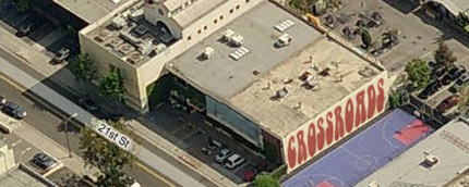
Why don't Americans know their geography or history? A big part of the problem is institutions like Crossroads School, the super-exclusive K-12 in Santa Monica where Hollywood stars send their kids. Transformers director Michael Bay is a Crossroads alum, which may help to explain the geographic illiteracy endemic in his films.

Steeped in the religion of post-modernism, Crossroads teaches that right answers aren't really important. Here are actual quotes straight from their web site. You won't believe this:

CROSSROADS
--We believe that the process of learning is more important than the product or “right answer”
--We view students as thinkers with emerging theories about the world rather than as recipients of knowledge from the teacher.
--We believe that students learn from one another and from the world around them rather than solely from the teacher.

This explains why Crossroads graduate Michael Bay dropped Israel from the map in Transformers 2... he wasn't pressured to worry about all those silly facts in school. I can almost hear the teacher telling little Michael, "If you don't think Israel is a country, that's fine. And if you think 2+2=5.... that's your right as an empowered person." So we can't really blame Michael Bay for errors like 
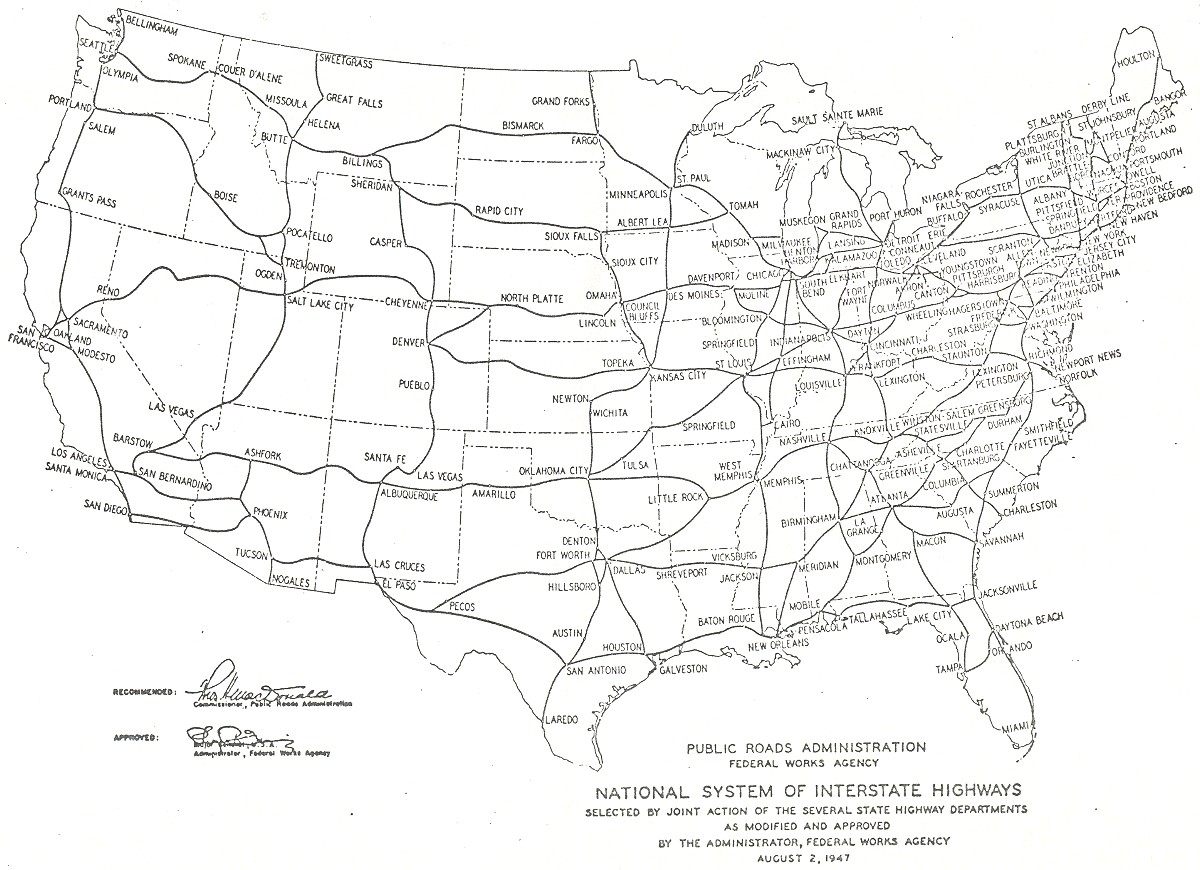
putting Washington DC in Illinois. The blame begins at places like Crossroads—the school that is prepping the famous of tomorrow (like alum Spencer Pratt).

If you don't see the shortcomings of the Crossroads approach to education, imagine this... let's say you are looking for a doctor to do your heart surgery. Would you want a surgeon trained at a medical school that espouses the Crossroads philosophy? Imagine Crossroads Medical School... "where we believe that students learn from one another and from the world around them --not from an experienced surgeon. We encourage surgical students to cut where it feels right... and develop their own modes of surgical expression unhindered by traditional knowledge." 

In fairness, the teachers at Crossroads are all probably nice people who think they are doing the right thing. They actually believe that indoctrinating kids in the "there-is-no-truth" philosophy of post-modernism is a good thing. I would argue that there are facts. And there is an objective right and wrong. History matters. Autobots are good and Decepticons are bad (At least Michael Bay got that one right!)

California split approved by state legislature

It's true. The California state legislature approved splitting the state in two... back in 1859. The US Constitution Article IV Section 3 states that all it takes to split a state (and thus create a new state) is to get approval of the state legislature and the US Congress. Signoff by a state legislature has occurred three times in American history.
1) Massachusetts voted to set its northern district free to become Maine in 1820.
2) In the Civil War era, the "restored" Virginia government voted to create West Virginia. (There is considerable dispute about the legality of this vote, however).
3) California's legislature voted to split the state in two in 1859.

The first two votes resulted in new states, but California never got officially sliced. Why? The US Congress refused to ratify the plan, because they were worried that a new state would upset the tenuous balance between north and south. Of course, that "balance" was upset shortly thereafter anyway—when the Civil War broke out. Above is the split that the California legislature approved... hoping to create the new state of "Colorado." This week, California legislator Jeff Stone proposed a new split. But his goofy plan certainly doesn't have the support that the 1859 plan had. Hmmm. Maybe in some dusty back room in the US Capitol, the 1859 plan is still sitting there, waiting for Congress to finally give it the thumbs up.

California split - a bad good idea

There's been talk in the last few days of splitting California to create the 51st state, but advocates have the names all wrong. (OK, the idea is lame too, but we'll get to that in a minute.) Jeff Stone, a Republican Riverside County supervisor proposes splitting California along the lines in the map above. He calls the new states "North California" and "South California." Seriously? He has Los Angeles in North California. He's also put cities that are further north than San Francisco (like Bridgeport) in South California. Huh? A much better name for these two states would be East California and West California. Or better yet, since Stone's real goal to to separate Republicans from Democrats, he might consider my naming suggestion in the bigger map above.

It's true that California should have split a long time ago... and it almost did in 1859 (Watch our video on this). But any proposal that puts Los Angeles and San Francisco in the same state... no one will take that seriously. More on the scheme here. 

Michael Bay drops Israel from the map

The second Transformers movie concludes with a big battle near the border between Egypt and Jordan. The problem: there is no such border. The two nations don't meet. Israel is in-between. In fact, Israel was totally eliminated from the movie... even though the Israeli air force would have been handy in fighting the Decepticons. This isn't Michael Bay's only head-scratching geography error. In the current Transformers movie, he puts Washington DC in Illinois.  Hey, I realize the Transformers movies are not meant to be educational films, but these errors (and lots of others) show the contempt Michael Bay has for his audience. He has to assume that viewers are so stupid, they won't notice this stuff. Maybe he's right. If so, we're all in deep trouble. (That reminds me, I should probably check the DVD of Bay's Pearl Harbor. It wouldn't surprise me if—in Bay's version—the U.S. was attacked by China.)